The water cycle in the Imlil Valley
Overview
The Water Cycle is a key topic studied across all AS/A level specifications. Students need to understand the inputs, stores, transfers and outputs and appreciate factors affecting variations in magnitude and change (spatially and temporally).
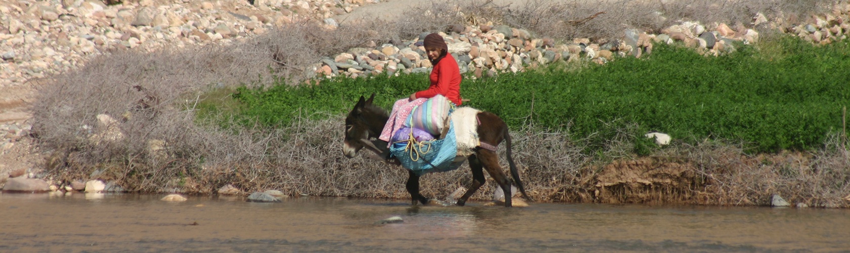
Imlil provides excellent opportunities for students to reinforce their understanding of the water cycle by applying their knowledge to the landscape in the Imlil valley. The ideal location for this is on the roof terrace at the Kasbah du Toubkal which affords panoramic views of the area.
Resources
- Resource 1:
Download Water Cycle in the Imlil valley
An introduction to the hydrological and basin characteristics affecting the water cycle. - Resource 2:
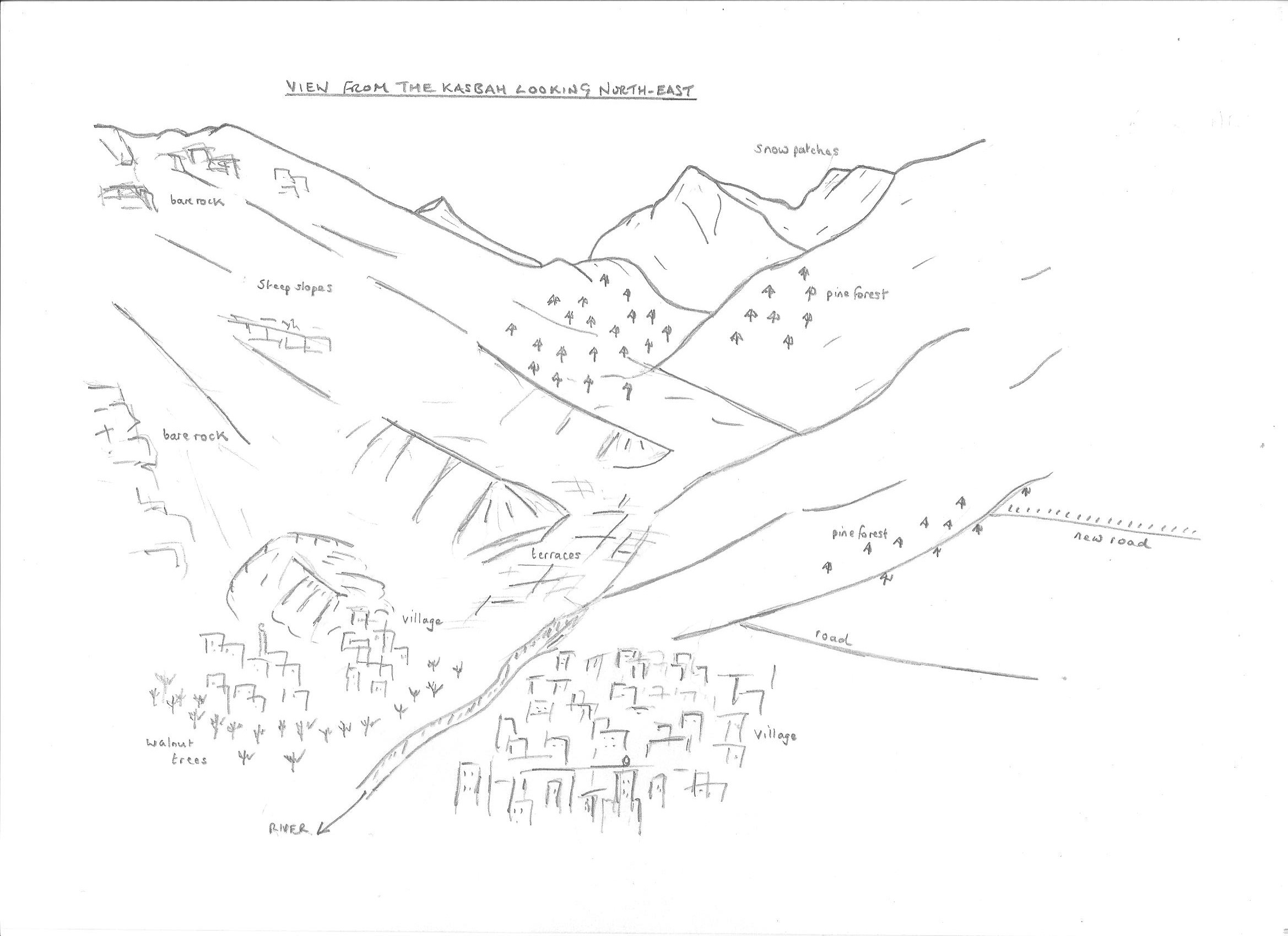
Download Field sketch view from Kasbah du Toubkal
This provides students with a basic sketch outline to support a detailed annotated sketch to show aspects and factors affecting the water cycle. - Resource 3:
Download Water balance in the Rehraya catchment
An excerpt from an academic study considering aspects of the water balance with clear links to flash flooding. - Resource 4:
Download Rivers and flooding in the High Atlas
This detailed report outlines factors affecting flooding, with detailed reference to the Imlil flood 1995.
Video of 2019 flood in Imlil Valley:
https://www.facebook.com/watch/?v=685015435351649 - Resource 5:
Download Water cycle field investigations
This gives some suggestions for field investigations associated with the water cycle. Details of techniques are widely referenced in field textbooks. - Resource 6:
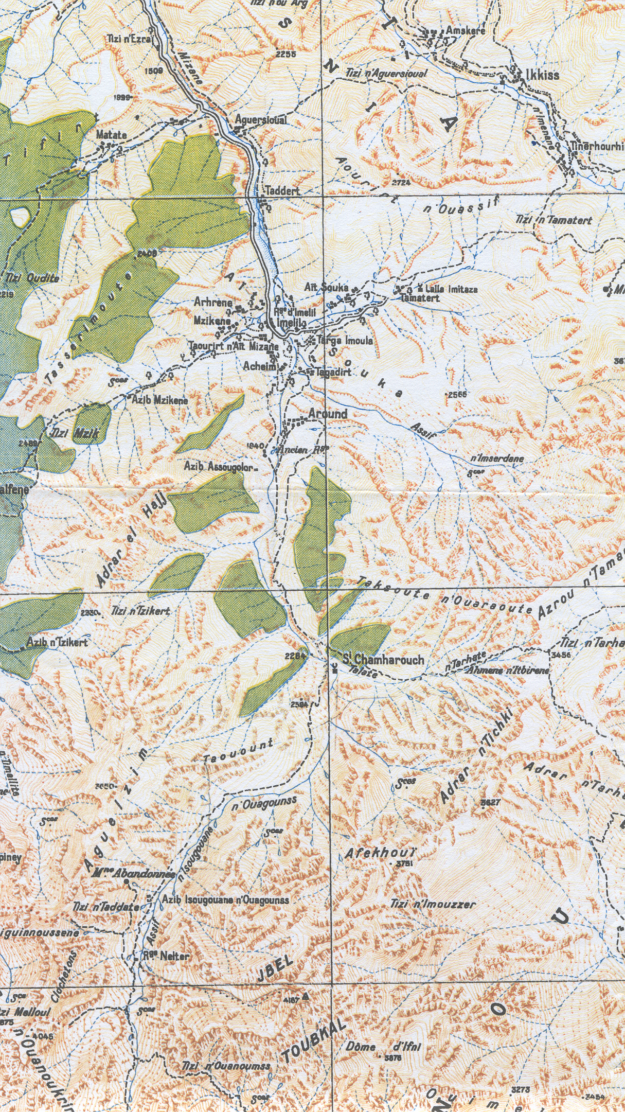
Download Imlil valley Map
An introduction to the opportunities for studying aspects of the carbon cycle. - Resource 7:
Download PhD Thesis Rehraya River (in French) - Resource 8.
Download The Mohammed VI Museum of Water Civilization
The Mohammed VI Museum of Water Civilization, the first of its kind dedicated to Moroccan, Arabic and Muslim’s hydraulic heritage, is a mix of archaeological museum that demonstrates the importance of water in the country.
Student activities
The Imlil area provides an excellent opportunity for students to apply their knowledge and understanding of the water cycle in an unfamiliar setting. Through observation and discussion, along with the use of annotated sketches and photos, students should be able to reinforce their understanding of these key topics and ‘see’ at first hand the interrelationships and linkages that exist between the various components.
- From a suitable viewing platform, for example the rooftop terrace at the Kasbah du Toubkal students can consider the various components of the water cycle. It is possible from this vantage point to consider most aspects of the water cycle and to suggest the relative importance of each component. Observations can be collated in a table or by means of a simple diagram. (See Resource 1)
- Students could be asked to draw a sketch map of a view from the roof terrace, adding labels and annotations that are pertinent to the water cycle. A simple base sketch map (Resource 2) is included in the resource folder – students could add further details to the sketch, such as villages, roads and trees, and write annotations to describe aspects of the water cycle.
- Having completed the activities above, students could attempt to draw a water cycle diagram for the Imlil valley.
- Students could consider the factors affecting the water cycle and extend this by considering the factors affecting – or contributing to – the flood risk. Imil has a history of flash flooding; what are the factors leading to this and how could they be controlled in the future?
- Students could consider the role of tree planting in the area. How might this reduce the flood risk and where should the trees be planted most effectively?
- By means of follow-up, students could attempt essay questions, for example:
- Discuss the factors affecting the magnitude of flows and stores in the Imlil valley
- Discuss the factors affecting change in the water cycle in the Imlil valley
(See Resource 5 for practical field activities)
Water balance
- Students can use Resource 3 to investigate the water balance in the context of a semi-arid mountain region. Hydrological and catchment characteristics can be used to explain the balance between precipitation and streamflow (runoff) enabling comparisons to be made with river basins in the UK and elsewhere.
- Resource 4 can be used to enable students to investigate the causes and impacts of the Imlil flood of 1995. This study can be supplemented with present day observations and fieldwork together with a study of the water cycle components.
(See Resource 5 for practical field activities)
- Download all resources (zipped folder)
- To download resources in Microsoft Word format for editing etc., please contact us via the contact page.


